logo
Home > Products >
Cable Fault Locator
>
XHGX507C1 Underground Pipeline Detector Water Gas Utility Mapping 300V 15W

XHGX507C1 Underground Pipeline Detector Water Gas Utility Mapping 300V 15W

Product Details:
Place of Origin: Shaanxi
Brand Name: XZH TEST
Certification: CE/ISO
Model Number: XHGX507C1
Detail Information
Place of Origin:
Shaanxi
Brand Name:
XZH TEST
Certification:
CE/ISO
Model Number:
XHGX507C1
Highlight:

High Light

Highlight:

Municipal Pipeline Network Mapper

,

Water Gas Utility Line Detector

,

Multi-Pipe Underground Route Tracer

Trading Information
Minimum Order Quantity:
1unit
Price:
Negotiable
Packaging Details:
wooden packaging
Delivery Time:
5-8work days
Payment Terms:
T/T
Supply Ability:
100 unit per month
Product Description
XHGX507 · UNDERGROUND UTILITY LOCATOR
XHGX507C1 Underground Pipeline Detector Water Gas Utility Mapping 300V 15W
C1 configuration
0–20 m depth
300 V direct output
1–20 cable ID

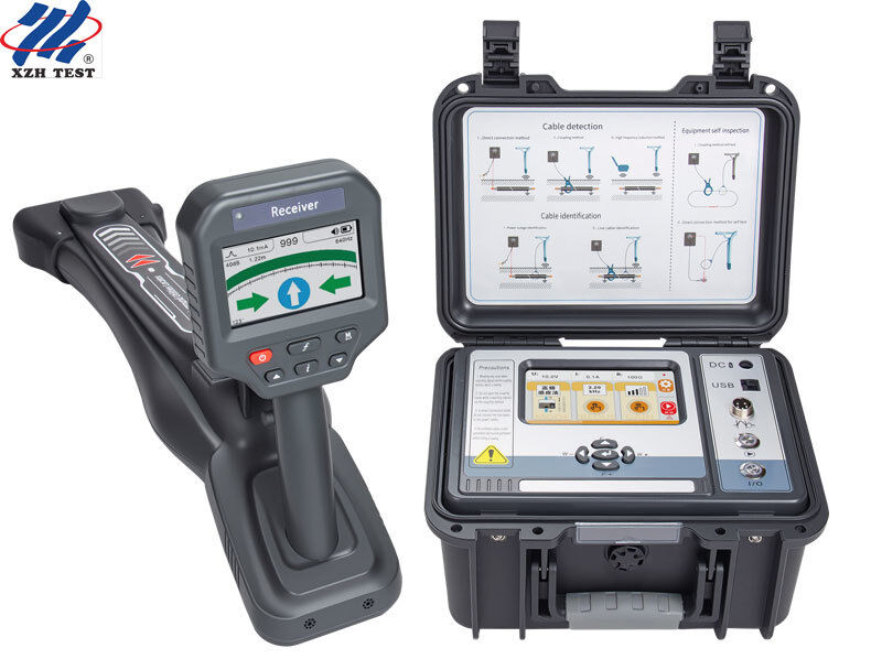
The XHGX507C1 is a pipeline and cable locator for municipal water and gas utility mapping. It traces metal pipelines and underground cables without excavation, displays route direction, measures depth and current, and identifies one cable among up to 20.

The transmitter provides 11 active frequencies from 640 Hz to 197 kHz, 15 W maximum output in 9 levels and 300 V maximum direct output. The receiver uses a 4.3-inch high-brightness colour touch screen and a 200 mm flexible current clamp. C1 includes an optional GPS drawing mode.

Product View
Underground Cable Pipe Locator Tester Electric Cable Fault Locator Utility Metal Detector
Who This Locator Is For

For municipal water and gas utility departments, pipeline maintenance crews and municipal mapping teams that need route, depth and cable ID records.

Municipal water and gas network teams mapping buried metal pipelines and verifying route and depth before excavation.
Pipeline maintenance crews tracing a target line among congested utilities and recording depth and current along the route.
Utility mapping teams that need cable identification up to 20 cables and optional GPS drawing records for GIS updates.
Receiver Specifications
ParameterSpecification
FunctionPipeline detection (cable position tracking, direction display, depth measurement, current measurement), cable identification, A-frame fault finding (optional)
Power8.4 V – 5200 mA rechargeable lithium battery
InputBuilt-in receiving coil, flexible current clamp, A-frame (optional)
Receiving frequencyActive: 640 Hz, 1.28 kHz, 2.56 kHz, 3.20 kHz, 4.09 kHz, 8.19 kHz, 10.2 kHz, 32.7 kHz, 65.6 kHz, 81.9 kHz, 197 kHz; passive: 50 Hz, 60 Hz, 250 Hz; RF: 32.7 kHz, 65.6 kHz, 81.9 kHz, 197 kHz
Detection modeBroad peak, narrow peak, valley
Detection displayClassic positioning, wire cruise, signal distortion measurement; GPS drawing mode (optional)
GPS drawingOptional
Detection rangeDirect: 0–20 km; coupling: 0–10 km; induction: buried depth below 2 m
Depth and currentReal-time cable depth and current display
Depth range0–20 m
Depth accuracyCenter axis position: ±5 % (0–3 m depth), -10 % (3–20 m depth)
Interference displayGreen: no interference; green: good; red: severe interference
Cable identificationFlexible clamp intelligent identification; 1–20 cables; 75 %–135 % current ratio; direction must match
Cable ID rangeDirect: 0–8 kΩ (0–20 km); coupling: 0–1 kΩ (0–6 km)
Display4.3-inch LCD colour screen, high brightness, visible in sunlight; capacitive touch
DimensionsApprox. 350 mm × 155 mm × 700 mm
WeightApprox. 2 kg
InterfaceType-C USB, aviation socket
Coil inner diameterφ200 mm (larger sizes customizable)
Working temperature-10 °C – 40 °C; below 80 % RH
Storage temperature-10 °C – 50 °C; ≤95 % RH, no condensation
Withstand voltageAC 2000 V/rms between front and rear shell
SafetyIEC61010-1 CAT III 600 V, IEC61010-031, IEC61326, pollution degree 2
Transmitter Specifications
ParameterSpecification
FunctionMultiple frequency signal transmission
Power11.1 V rechargeable lithium iron phosphate battery
Output methodsDirect connection, coupling, induction
Output frequency640 Hz, 1.28 kHz, 2.56 kHz, 3.20 kHz, 4.09 kHz, 8.19 kHz, 10.2 kHz, 32.7 kHz, 65.6 kHz, 81.9 kHz, 197 kHz
Output modeAutomatic recognition by connected accessory
Output power15 W max, 9 adjustable levels
ImpedanceFully automatic real-time impedance matching and protection
Direct output voltage300 V max
Circuit protectionOverload and short-circuit protection
Display5-inch LCD colour screen; capacitive touch
DimensionsApprox. 320 mm × 275 mm × 145 mm
WeightTransmitter approx. 3.85 kg; transmitting clamp approx. 1.18 kg
ChargerDC 11.1 V 3 A
Clamp dimensions297 mm × 194 mm × 39 mm
Clamp inner diameterφ125 mm
Clamp cable length3 m
Test lineRed 3 m, black 3 m
InterfaceUSB, DC, aviation socket
Pressure resistanceIntegrated tool-box body, approx. 200 kg
Withstand voltageAC 3700 V/rms between top and bottom of case
EMCIEC61326 (EMC)
SafetyIEC61010-1 CAT III 300 V, CAT IV 150 V, pollution degree 2
Frequently Asked Questions
Q1.What can the XHGX507C1/C2 locate?
It traces metal pipelines and underground cables without excavation, displays route direction, measures depth and current, identifies one cable among up to 20, and supports optional A-frame fault finding.
Q2.How deep and how far can it detect?
Depth range is 0–20 m. Direct connection generally reaches 0–20 km, coupling 0–10 km, and induction is used for cables buried less than 2 m.
Q3.How many frequencies are available?
There are 11 active frequencies from 640 Hz to 197 kHz, plus 50 Hz, 60 Hz and 250 Hz passive power frequencies and RF bands centred at 32.7 kHz, 65.6 kHz, 81.9 kHz and 197 kHz.
Q4.How does the 20-cable identification work?
Up to 20 cables can be calibrated as L1–L20 at the transmitter end. Identification succeeds when the received/transmitted current ratio is 75 %–135 % and the transmitting and receiving clamps point in the same direction.
Q5.What are the transmitter output and C1 configuration?
The transmitter uses an 11.1 V lithium iron phosphate battery, outputs 15 W maximum in 9 levels and provides 300 V maximum direct output. The C1 configuration provides an optional GPS drawing mode; Bluetooth and APP/RTK control are not included.

Ratings & Review

Overall Rating

4.7
Based on 50 reviews for this supplier

Rating Snapshot

The following is the distribution of all ratings
5 stars
67%
4 stars
33%
3 stars
0%
2 stars
0%
1 stars
0%

All Reviews

D
Daniel Thompson
United States May 13.2026
Been using this on commercial job sites for about 3 months now. For the money, it's hard to beat. Depth readings are surprisingly accurate — tested it against known lines and was within a few inches every time. The multiple frequency options really help cut through interference in busy areas, and the battery lasts a full workday no problem. Build feels sturdy enough for field use. Only knock: the screen can be a little hard to read in direct sunlight, and the manual's pretty bare-bones. If you're new to locating, expect a learning curve. Overall, great value. Does everything my old name-brand unit did for half the price. Would recommend to any contractor or utility tech on a budget.
C
Carlos Barbosa
Brazil Mar 19.2026
This XHGX507C1 tester is an absolute lifesaver for our farm power crews out in Mato Grosso’s soybean fields! It handles dusty, high-temperature farm terrain flawlessly, locks underground cable faults super fast without messy digging. Super tough build, battery lasts all day roaming wide farm lots, and cuts our field work stress down by half. Worth every real for rural utility maintenance!
R
Robert Davis
United States Feb 27.2026
Been using this locator on job sites for a couple months now — no regrets. Picks up lines deep and accurate, way better than my old unit. Love the 11 frequency options, really helps with interference in busy areas. Build feels sturdy, battery lasts all day. Manual's a bit thin for beginners, but if you know your stuff, it's straightforward. Honestly punches way above its price tag. Would recommend to anyone in utility locating or power maintenance.